The Dark Peak
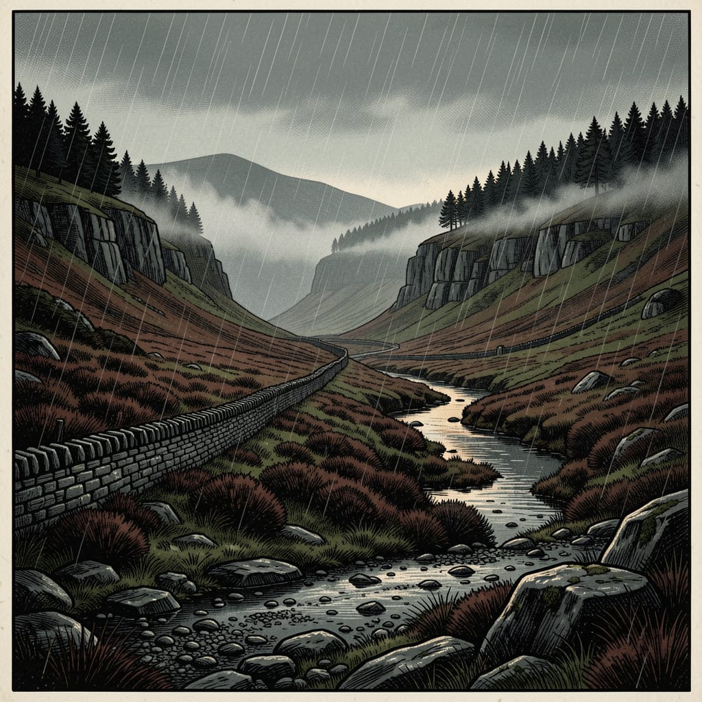
The Dark Peak occupies the northern, eastern and western fringes of the National Park, including all of the highest ground and most of the open moorland. The bedrock geology is the Namurian Millstone Grit: a coarse cross-bedded sandstone deposited some 318 million years ago, interbedded with thin mudstones and shales. The grit produces the characteristic Dark Peak landscape of horizontal edges (Stanage, Curbar, Froggatt, the Roaches), free-standing tors and boulders, and broad summit plateaux capped with blanket peat. The highest of these plateaux is Kinder Scout (636 m); Bleaklow (633 m), Howden Moors and Black Hill (582 m) form the surrounding upland complex.
The peat blanket covering the gritstone summits began to accumulate in the early Holocene, some 7,000 years ago, on the level plateaux where drainage was poor. It is the largest area of blanket bog in southern Britain, and one of the most ecologically and hydrologically significant. Substantial areas of the blanket have been severely eroded since the eighteenth century by the combined effects of overgrazing, atmospheric pollution from the surrounding industrial cities, and accidental fires; the Moors for the Future partnership has carried out extensive restoration work since 2003. The Dark Peak is, in summer, a country of cottongrass and heather; in winter, a country of mist, frozen peat and sudden short days.
The White Peak
The White Peak, occupying the southern and central core of the National Park, is built on Carboniferous limestone, deposited in shallow tropical seas around 340 million years ago. The limestone has been folded into a broad plateau dipping gently to the east, and incised by post-glacial rivers into the steep-sided dales which are the principal landscape feature of the area: Dovedale, Lathkill Dale, Monsal Dale, Chee Dale, and the famous Winnats Pass west of Castleton. The plateau between the dales carries pale drystone walls, hay meadows, and a markedly different flora from the gritstone country — calciferous grassland species rather than the acid-bog flora of the Dark Peak.
The White Peak has been a centre of lead mining since the Roman period, with workings continuing on industrial scale through to the early twentieth century. The cave systems of the limestone — the show caves of Peak Cavern and Speedwell Cavern at Castleton, Blue John Cavern and Treak Cliff Cavern on the slopes above, the Heights of Abraham caverns at Matlock Bath — were originally lead workings, mostly converted to commercial tourist attractions in the nineteenth and early twentieth centuries. Blue John, the rare blue-and-purple variety of fluorite, occurs in commercially exploitable quantities only on the slopes above Castleton.
History & The National Park
The Peak District has been more or less continuously settled since the Mesolithic period. Neolithic and Bronze Age monuments — chambered tombs, henges (notably Arbor Low, sometimes called ‘the Stonehenge of the North’), stone circles and bowl barrows — survive in considerable numbers across the limestone uplands. The Iron Age was marked by the construction of upland hill forts, of which Mam Tor, on the ridge between Hope and Edale, is one of the most prominent in the central Peak. The Roman period brought military occupation of the river valleys and the establishment of Aquae Arnemetiae at modern Buxton, one of only two named Roman bath towns in Britain.
The medieval landscape of the central Peak was dominated by the Royal Forest of the Peak, a Crown hunting preserve administered with some rigour through the eleventh to fourteenth centuries. Edale Cross, on the high moor at the head of Winnats Pass, preserves the boundary marker of three of the Forest's administrative wards: Hopedale, Longdendale and Campana.
The drive for public access to the Peak's moorland is a story of the twentieth century. Through the nineteenth century, increasing population in the surrounding industrial cities — Manchester, Sheffield, the Lancashire mill towns — produced a growing weekend-rambler movement seeking access to the high moors for recreation. The moors themselves remained, throughout this period, the private property of grouse-shooting estates, and trespass on them was prosecuted. The 1930s rambling movement, led by the British Workers' Sports Federation under Benny Rothman, took the position that this exclusion was illegitimate.
The defining act of the rambling movement was the Mass Trespass on Kinder Scout on Sunday 24 April 1932, when approximately four hundred trespassers ascended the plateau from Hayfield in defiance of the landowners' exclusion. Six were arrested; five imprisoned. The political consequences took two decades to work through, but produced — first — the National Parks and Access to the Countryside Act 1949, and second, the designation of the Peak District as the United Kingdom's first National Park on 17 April 1951. The principle of public access to open moorland was eventually established in statute, half a century after the Trespass, by the Countryside and Rights of Way Act 2000.
The National Park today is governed by the Peak District National Park Authority, from its headquarters at Aldern House in Bakewell. It is classified by the IUCN as Category V (Protected Landscape) — a designation that recognises the Park as a populated, working landscape rather than a wilderness reserve. Approximately 38,000 people live within its boundaries; some 13 million day-trips are made to it each year.
Towns & Villages
The Peak District is, unlike most British National Parks, a substantially-populated working landscape. The principal settlements within or on the boundary of the Park, all with dedicated Archive entries, include:
Spa town at 300 m, on the western edge of the White Peak plateau. The largest market town in the Peak District; the Roman Aquae Arnemetiae. Just outside the Park boundary by 1951 designation, but the Park's effective western gateway.
Market town in the Wye valley; the only town wholly within the National Park boundary. Population around 4,000. The administrative seat of the Park Authority at Aldern House.
County town of Derbyshire, on the lower Derwent at the southern edge of the National Park. Seat of Derbyshire County Council in the former Smedley's Hydropathic establishment.
Village and civil parish in the Vale of Edale, at the southern foot of Kinder Scout. The southern terminus of the Pennine Way.
The highest point of the National Park at 636 m. A gritstone plateau on the southern edge of the Dark Peak. Site of the 1932 Mass Trespass.
Medieval wayside and boundary cross on the high moorland between Hayfield and Edale, marking the junction of three wards of the former Royal Forest of the Peak.
The seat of the Dukes of Devonshire on the lower Derwent. One of the principal great houses of England; just outside the National Park boundary but conventionally treated as a Peak District destination.
The A57 trans-Pennine road, crossing the Dark Peak between Sheffield and Manchester. One of England's most dramatic upland roads, frequently closed in winter.
Fictional village on the high plateau at the head of Winnats Pass, west of Castleton. The primary setting of the Book of Thoth Saga; positioned within real Peak District geography but not corresponding to any real settlement.
Role in the Saga — Cambion spoilers
Contains plot reveals from Book One.
The Peak District is the principal landscape of the entire Book of Thoth Saga. It is not a passive setting: it is treated through Cambion as an indifferent, ancient presence whose stable geology and predictable weather are the larger frame within which the much smaller, more frantic human events of the saga play out. The framing is most explicit in Chapter Forty, when the narrator concludes that the Peak District had no opinion on this; the gritstone was older than the calendar, and the mist came off Kinder Scout just as it always had, without ever consulting the date.
Seasons across the saga. The novel is experienced across all four Peak District seasons, none of which is gentle. Behind Stepping Stones Primary, the heather on the peaks is still brown — too early for colour as Robert stands at the school fence. December creeps into the peaks overnight, frost armouring the roofs into a thin silver shell. Late April arrives with furious showers, rain hammering roof and windows in steady percussion as Ben leaves the house before five. One wet Thursday in September arrives smelling of mud, dead leaves and the particular rot the Peaks save for autumn. The Knight household keeps its heating on through long November evenings when the bills pile up like accusations. The hills are present in the way that things are present when they are bigger than the watcher and older than the watcher and do not especially care.
The Peaks as ground. The laminated OS maps of the Dark Peak pinned above the fire at the Rail and Reservoir and in Ben Knight's room place his relationship with the moors as terrain rather than scenery. He is not a man who uses the country for recreation; he is a man who has been planning routes and fall-backs across it for years, because the high ground above Hope's End is the most likely approach for anyone coming at the family from the north without being seen. The Kinder night encounter of Chapter Thirty (see the Kinder Scout entry) is the most explicit single demonstration of this. The Pennine moorland around the village is, in operational terms, the perimeter.
The Peaks as concealment. The Orion static signals-relay near Edale Cross exploits the line-of-sight signal corridors over the western edge of the Dark Peak toward Manchester. The unidentified woman planting Mammon coins moves through five Peak District market towns — Derby, Matlock, Bakewell, Chesterfield and Sheffield — using the Peak District's working market towns as the cover for her deliveries, the unconsidered hand-to-hand passage of cash absorbing the anomalous coin without examination. The geography of the Peak is, throughout the saga, the cover provided by the region's ordinariness over the activity moving through it.
The Peaks as return. Late in the novel, in Chapter Fifty, Robert is being driven home from hospital with a Peaks FM traffic update for the Snake Pass murmuring at the nurses' station behind him. He watches the landscape close in as the car sinks into the valley — the open fell narrowing to drystone walls, the walls to terraced stone, until only the road remains, hemmed by the weight of the hills. The High Peak has gone on, vast and indifferent. The valley is just where he left it. The Peak District's function across the saga is precisely that — the reassurance and the threat of being unchanged.
Trivia
- The Peak District National Park, designated on 17 April 1951, was the first National Park created in the United Kingdom under the National Parks and Access to the Countryside Act 1949. The Lake District, Snowdonia and Dartmoor followed in the same year; today, the United Kingdom has fifteen National Parks in total.
- The Park's area — some 555 square miles — makes it one of the larger English National Parks. Its location, within an hour's drive of Manchester, Sheffield, Derby, Nottingham and Stoke-on-Trent, places it within the commuting belt of approximately 16 million people, more than any other National Park in the world.
- The peculiar name Peak District derives from the Old English peac, related to the modern words peak and peck, used in the early medieval period as a general term for upland country rather than for the kind of pointed mountain summit the modern English meaning would suggest. The Anglo-Saxon Chronicle records the region as Peaclond, ‘Peak-land’, with the related territorial unit Pecsaetan, ‘the Peak-dwellers’, an Anglian tribal group of the seventh century.
- Roughly 13 million day visits are made to the Peak District National Park each year; some figures place the total higher when overnight stays and through-traffic are included. By visitor numbers, it is among the most-used National Parks in the world.
- The clear visual line between the dark gritstone moorland of the north and the pale limestone country of the south is one of the more dramatic geological transitions visible at the human scale in Britain. The change happens over a single short valley or a couple of fields, with everything from soil colour to wall stone to grazing flora shifting at the boundary.
- The Moors for the Future partnership's blanket-bog restoration programme on the Dark Peak summits, undertaken since 2003, is one of the largest peat restoration projects in Europe. The Sphagnum re-introduction programme has re-vegetated thousands of hectares of previously bare peat, with consequences for the Park's carbon storage, water management and ecological recovery.
- The Peak District is the closest National Park to any of the great industrial cities of the Midlands and the North — Manchester and Sheffield are visible from its higher edges on clear days. Both cities have, since the nineteenth century, treated the moors above them as the public lungs of their populations, and the political pressure for public access in the early twentieth century came primarily from their working populations.
Appearances